
Прецизното земеделие е бъдещето на съвременното селскостопанско производство
Author(s): д-р Марина Стоянова, ИПАЗР, „Н. Пушкаров“, София; доцент д-р Веселин Кутев, Лесотехнически университет в София
Date: 23.10.2018
12698
The soil is quite diverse in its nature and can significantly change its characteristics within a few meters. Therefore, the current system for soil sampling of agricultural land for assessing its fertility, based on taking an average sample from large plots, does not provide a realistic idea of the needs of the plants at a specific location. Under this system, during fertilization the plants receive an average dose of nutrients, which is optimal for some of them, insufficient for others, and excessively high for the rest. In this way, the efficiency of fertilization decreases and funds are lost due to the ineffective use of fertilizers by the plants. In plants that receive a lower than required fertilizer dose, reduced quality and lower yield are observed, while in those fertilized with more than the necessary doses, the yield may be reduced under the influence of diseases, pests and adverse weather conditions as a result of the excessive development of the crop. This is particularly important to be taken into account on low-productive soils – acidic and saline.
The National Research Council of the USA (1997) provides a definition of precision agriculture: “Precision agriculture is a management strategy that uses information technologies to integrate data from multiple sources for making decisions related to agricultural production.” The concept of modern precision agriculture has advanced with the support of technological changes in information technologies – powerful computers, affordable GPS equipment and the availability of sufficiently accurate and informative imagery from satellites, aircraft and drones. This allows more precise management of land and agriculture. The management unit is now the field, and the variability of the soil within a field becomes the focus of research.
Basic steps in precision agriculture:
I. Determining the parameters of spatial variation
II. Managing the variation
III. Overall assessment
Sampling on a grid provides sufficient information on the spatial variation of the soil indicators in the field. Nevertheless, this is a labor-intensive process, and the subsequent soil analyses are quite expensive. Existing technologies allow us to understand spatial variation and, by providing specific agronomic recommendations for each location, to manage it and enable the development of precision agriculture. Thus, dozens of soil samples can be reduced to a few.
A key indicator is the presence of profitability from the newly implemented activities. The potential for improving environmental quality is a main objective of such activities – reduced use of agrochemicals, increased efficiency of nutrient uptake, reduced soil degradation and others.
Accurate information regarding soil and crop parameters in the fields is crucial for the precise management of agriculture.
We may regard precision agriculture as a risk management tool through its potential to reduce the degree of yield variability. Technological progress in communication, together with the information revolution, has made it possible to revive the concept of precision agriculture and to apply it on a larger scale. Precision farming technologies, such as the Global Positioning System (GPS), Geographic Information Systems (GIS), remote sensing, yield monitoring and variable rate fertilization systems, make it possible to manage spatial variation in the field on a large scale.
A very important aspect when introducing a new technology is the economic assessment of this innovation. Precision agriculture started with quite acceptable results. In a study of 108 published articles with economic data, 63% provide a positive assessment of a given precision agriculture technology, 11% – a negative result, and 26% – mixed. In seeking methods to optimize the application of inputs in the field, improve yield and product quality, and protect the environment, some farmers are turning to precision agriculture. The use of unmanned aerial vehicles (UAVs or drones) is finding increasingly widespread application in precision agriculture. From multispectral imagery of fields and crops to spraying and seeding, their use and development are attracting growing interest in the public sector. The technology forms the basis for applying variable-rate fertilization, in accordance with soil differences and crop requirements at specific locations within the field. Variable-rate fertilization is used on more than half of the areas with major crops in the USA. Through the use of additional sensors and equipment, the technologies assist us in making management decisions related to several key issues:
- Soil and terrain conditions
- Growth stage and condition of the crops
- Stand density and thickness
- Crop nutrition and fertilization
- Irrigation
- Development of diseases and pests
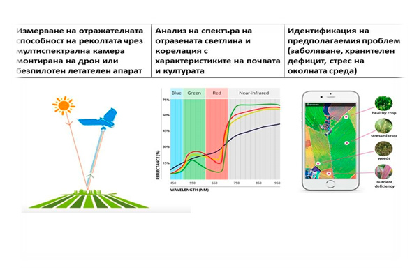
With the introduction of satellite systems into everyday life, their widespread use for monitoring crops from the air has also begun. The use of UAVs is a natural process associated with transferring remote sensing methods from the macro- to the micro-level within farms. Their rapid adoption is largely determined by a number of advantages over traditional remote sensing methods. The drone system enables the collection of high-resolution imagery below cloud level and at any time. Inexpensive and easy to use, most drone systems are automated. The information generated is used to produce a raster map, and the accuracy is determined by the altitude at which the surveys are conducted. The process of obtaining the images is carried out in five main steps:
- Flight planning
- Carrying out the flight and acquiring images
- Assembling the orthophoto mosaic
- Visualization of the geospatial results
- Expert analysis and transfer of the results to the field
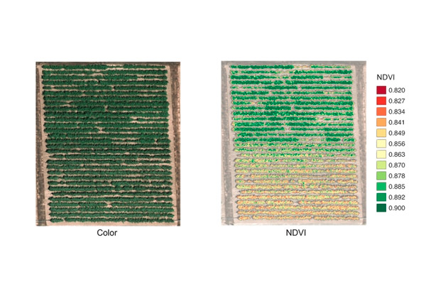
The final product is orthophoto imagery of various vegetation indices (VI) such as the Normalized Difference Vegetation Index (NDVI), the Green Normalized Difference Vegetation Index (GNDVI), the Soil-Adjusted Vegetation Index (SAVI), for the analysis of the health and vitality of various agricultural crops.
Precision agriculture is the future of modern agriculture. Farmers are beginning to apply it and soon this will be the main method for managing agriculture.
The article is part of the content of issue 8/9 2018 of the journal “Plant Protection”

